News
Go under the sea with Google Street View ocean images
Google wants to get everywhere with Street View and it’s now taken its cameras into the deep. Today, you can see imagery captured in oceans across the world

It seems these days Google is just about everywhere. You can pull up Google Earth and travel to space from galaxy to galaxy, or you could launch Google Maps and walk down the street you grew up on using Street View. Starting today, we can add another item to the list. Google is taking you underwater.
The newest addition allows users to explore brand new Street View imagery of more than 40 locations around the world, including the American Samoa and Chagos Islands and underwater dives in Bali, the Bahamas and the Great Barrier Reef.
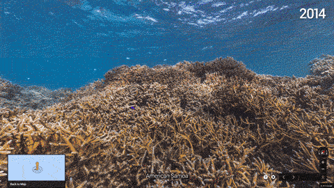
It seems like Google’s efforts isn’t all for show either. The whole idea of this project isn’t for us to look at mermaids and cool looking fish, it’s actually to show the magnitude of damage we’re causing to one of our largest natural resources.
“We hope the release of this imagery inspires people to learn more about this precious natural resource.”
Either way you look at it, it’s a fun way to explore the world beyond your eyes. To learn more, click here.
Follow us on Flipboard, Google News, or Apple News


Virtual Reality
Asus, Lenovo, and Xbox partner with Meta for VR expansion